Revision as of 18:18, 5 August 2009 (edit)
Admin (Talk | contribs)
← Previous diff |
Current revision (14:21, 22 May 2010) (edit)
Admin (Talk | contribs)
|
| Line 1: |
Line 1: |
| | + | {{Template:Gazetteer Local NorthStoneham}} |
| | + | |
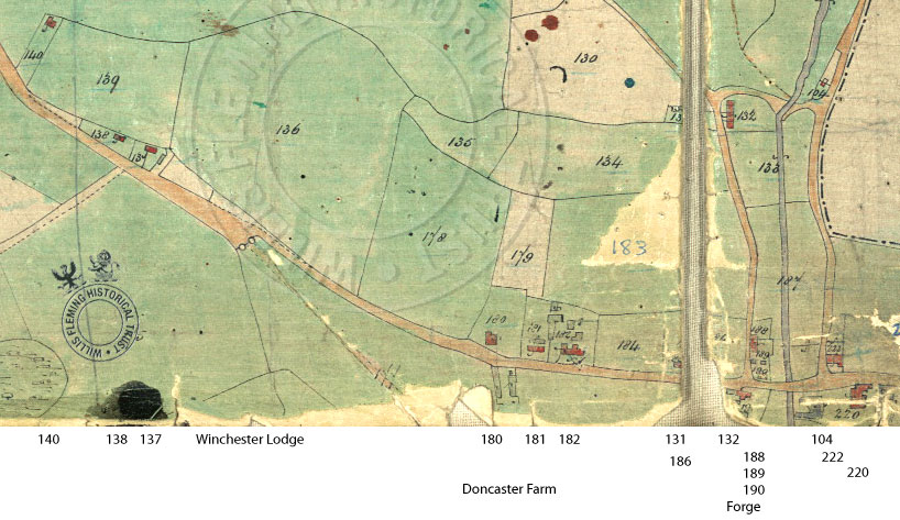
| | '''Middle Stoneham''', also known as plain '''Middle''', or '''Middle Street''', was a scattered village at [[North Stoneham]] on the [[Stoneham Estate]], and is often described as 'North Stoneham village', although there was no village of that name. Middle Stoneham adjoined the northeast boundaries of [[North Stoneham Park]]. The area south of the village was known as the Church End. | | '''Middle Stoneham''', also known as plain '''Middle''', or '''Middle Street''', was a scattered village at [[North Stoneham]] on the [[Stoneham Estate]], and is often described as 'North Stoneham village', although there was no village of that name. Middle Stoneham adjoined the northeast boundaries of [[North Stoneham Park]]. The area south of the village was known as the Church End. |
| - | {| border="0" bordercolor="#CCCCCC" cellpadding="4" cellspacing="4" cellspadding="5" align="center" style="background:#F9F9F9; border:1px dashed gray; margin: 1em" | + | {{Quotebox yellow | quote='''History of Middle Stoneham walk''', Sun 4 October 2009, 2pm; meet at the [[Stoneham War Shrine]]. A guided walk with Hamble Valley Heritage Guides around Middle area, taking in Magpie Lane, Chestnut Avenue, Stoneham Lane, and comparing pictures of how the area appeared in days gone by, to how it is today. Led by Eric Reed.''}} |
| - | |- | + | |
| - | |''Event: History of Middle Stoneham walk, Sun 4 October 2009, 2pm; meet at the [[Stoneham War Shrine]]. A guided walk with Hamble Valley Heritage Guides around Middle area, taking in Magpie Lane, Chestnut Avenue, Stoneham Lane, and comparing pictures of how the area appeared in days gone by, to how it is today. Led by Eric Reed.'' | + | |
| - | |} | + | |
| | | | |
| | ==Selected views== | | ==Selected views== |
| Line 9: |
Line 8: |
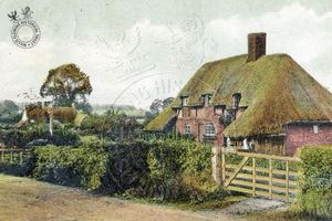
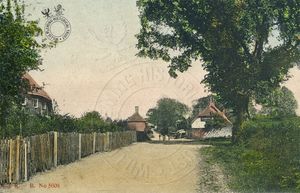
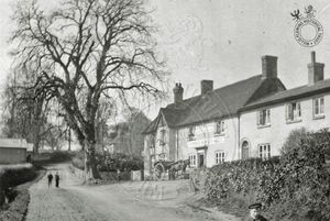
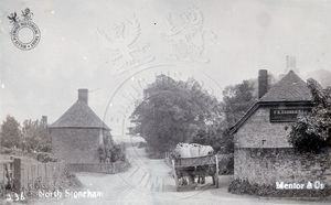
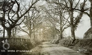
| | {{Template:FourImages | a1image=[[Image:Middle_Durmans.jpg|300px]] | a1caption=Middle Stoneham from postcard c.1910, looking northwest from Stoneham Lane: [[Durmans]] farmhouse (right) with glimpse of rear of [[Stoneham Estate Cottages Nos. 37-38|Cottages No. 37-38]] beyond (left). | a2image=[[Image:Middle_postcardview.jpg|300px]] | a2caption=Middle Stoneham from postcard c.1910, looking east along Chestnut Avenue: [[Stoneham Estate Cottages Nos. 32-33|Cottages Nos. 32-33]], Post House (left), [[Stoneham Estate Cottages Nos. 35-36|Cottages Nos. 35-36]] (centre) and [[Stoneham Estate Cottage No. 34|Cottage No. 34]], the Forge (right). | b1image=[[Image:WFMS_2694_px800.jpg|300px]] | b1caption=Middle Stoneham looking west along Chestnut Avenue with [[Cricketers Arms]] on right, and glimpse of [[Doncaster Farm]] buildings on left. | b2image=[[Image:Mentor236.jpg|300px]] | b2caption=Middle Stoneham c.1900, looking east from Chestnut Avenue along Stoneham Lane: [[Stoneham Estate Cottages Nos. 35-36|Cottages Nos. 35-36]] (left) and [[Stoneham Estate Cottage No. 34|Cottage No. 34]], the Forge (right).}} | | {{Template:FourImages | a1image=[[Image:Middle_Durmans.jpg|300px]] | a1caption=Middle Stoneham from postcard c.1910, looking northwest from Stoneham Lane: [[Durmans]] farmhouse (right) with glimpse of rear of [[Stoneham Estate Cottages Nos. 37-38|Cottages No. 37-38]] beyond (left). | a2image=[[Image:Middle_postcardview.jpg|300px]] | a2caption=Middle Stoneham from postcard c.1910, looking east along Chestnut Avenue: [[Stoneham Estate Cottages Nos. 32-33|Cottages Nos. 32-33]], Post House (left), [[Stoneham Estate Cottages Nos. 35-36|Cottages Nos. 35-36]] (centre) and [[Stoneham Estate Cottage No. 34|Cottage No. 34]], the Forge (right). | b1image=[[Image:WFMS_2694_px800.jpg|300px]] | b1caption=Middle Stoneham looking west along Chestnut Avenue with [[Cricketers Arms]] on right, and glimpse of [[Doncaster Farm]] buildings on left. | b2image=[[Image:Mentor236.jpg|300px]] | b2caption=Middle Stoneham c.1900, looking east from Chestnut Avenue along Stoneham Lane: [[Stoneham Estate Cottages Nos. 35-36|Cottages Nos. 35-36]] (left) and [[Stoneham Estate Cottage No. 34|Cottage No. 34]], the Forge (right).}} |
| | | | |
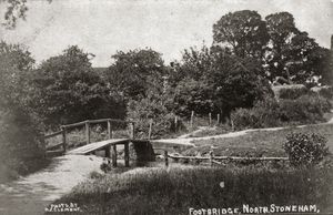
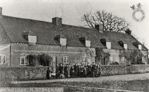
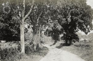
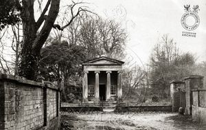
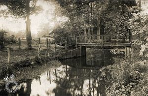
| - | {{Template:FourImages | a1image=[[Image:North_Stoneham_lane.jpg|300px]] | a1caption=Chestnut Avenue [?} | a2image=[[Image:StonehamShrine.jpg|300px]] | a2caption=[[Stoneham Estate Cottages Nos. 32-33|Cottages Nos. 32-33]], Post House.|b1image=[[Image:WFMS_2695_px800.jpg|300px]] | b1caption=Footbridge at [[Spring Lane ford]] crossing [[Monks Brook]] at the north end of Spring Lane, with glimpse of [[Stoneham Estate Cottages Nos. 39-44|Cottages Nos. 39-44]] at north end of Spring Lane | b2image=[[Image:EstateCottagesNos39-44.jpg|300px]] | b2caption=Middle Stoneham c.1900: looking southeast across Spring Lane at [[Stoneham Estate Cottages Nos. 39-44|Cottages Nos. 39-44]], a row of six cottages at the north end of Spring Lane.}} | + | {{Template:FourImages | a1image=[[Image:North_Stoneham_lane.jpg|300px]] | a1caption=Chestnut Avenue [?} | a2image=[[Image:StonehamShrine.jpg|300px]] | a2caption=[[Stoneham War Shrine]], built 1917.|b1image=[[Image:WFMS_2695_px800.jpg|300px]] | b1caption=Footbridge at [[Spring Lane ford]] crossing [[Monks Brook]] at the north end of Spring Lane, with glimpse of [[Stoneham Estate Cottages Nos. 39-44|Cottages Nos. 39-44]] at north end of Spring Lane | b2image=[[Image:EstateCottagesNos39-44.jpg|300px]] | b2caption=Middle Stoneham c.1900: looking southeast across Spring Lane at [[Stoneham Estate Cottages Nos. 39-44|Cottages Nos. 39-44]], a row of six cottages at the north end of Spring Lane.}} |
| | | | |
| | ==Gazetteer== | | ==Gazetteer== |
| Line 50: |
Line 49: |
| | |[[Stoneham War Shrine]]|||| | | |[[Stoneham War Shrine]]|||| |
| | |- | | |- |
| - | |[[Stoneham Estate Cottage No. 34|Cottage No. 34]] (Forge)|||| | + | |[[Stoneham Estate Cottage No. 34|Cottage No. 34]] (Forge)||191|| |
| | |- | | |- |
| | |[[Doncaster Cottage]]||220|| | | |[[Doncaster Cottage]]||220|| |
| | |- | | |- |
| - | |'''Spring Lane (Magpie Lane), east side from south'''|||| | + | |'''Spring Lane (Magpie Lane, Back Lane), east side from south'''|||| |
| | |- | | |- |
| | |[[Stoneham Estate Cottages Nos. 37-38|Cottages No. 37-38]] (inc. the White Cottage)||188 & 189|| | | |[[Stoneham Estate Cottages Nos. 37-38|Cottages No. 37-38]] (inc. the White Cottage)||188 & 189|| |
| | + | |- |
| | + | |[[5, Magpie Lane]]|||| |
| | |- | | |- |
| | |[[Stoneham Estate Cottages Nos. 39-44|Cottages Nos. 39-44]] (Terrace of six cottages)||132|| | | |[[Stoneham Estate Cottages Nos. 39-44|Cottages Nos. 39-44]] (Terrace of six cottages)||132|| |
| | |- | | |- |
| - | |'''Spring Lane (Magpie Lane), west side'''|||| | + | |'''Spring Lane (Magpie Lane, Back Lane), west side'''|||| |
| | |- | | |- |
| | | [[Stoneham Estate Cottages Nos. 45-46|Cottages Nos. 45-46]], known as Yonder Thatch||131|| | | | [[Stoneham Estate Cottages Nos. 45-46|Cottages Nos. 45-46]], known as Yonder Thatch||131|| |
| Line 73: |
Line 74: |
| | |- | | |- |
| | | Cottage (51?)|||| | | | Cottage (51?)|||| |
| | + | |- |
| | + | | [[St Nicolas Church Hall]] (The Green Hut) |
| | |- | | |- |
| | |'''Church End'''|||| | | |'''Church End'''|||| |
| Line 83: |
Line 86: |
| | |- | | |- |
| | | [[North Stoneham Church]]|||| | | | [[North Stoneham Church]]|||| |
| | + | |- |
| | + | |[[Old North Stoneham House]]|||| |
| | |- | | |- |
| | | Ford at [[Doncaster Drove]]|||| | | | Ford at [[Doncaster Drove]]|||| |

